Weather Blog: Severe Storms Bring High Winds, Heavy Rain With Isolated Tornado Risk

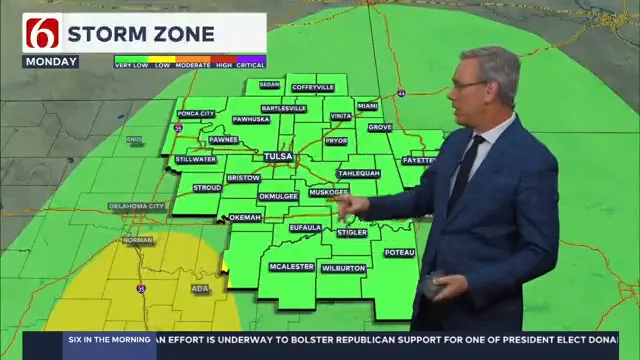
A powerful storm system will sweep through Oklahoma tonight into mid-day Monday, bringing strong winds, heavy rain, and a small risk of isolated tornadoes.
What to Expect
- High Winds: Gusts over 40 mph are likely overnight and into Monday morning, even outside of storms. These winds could lead to power outages and damage.
- Heavy Rain: Expect 1-2 inches of rain, with the heaviest amounts west and northwest of Tulsa.
- Severe Storms: A small tornado risk exists within a line of storms, especially Monday morning until around 2 p.m. Severe weather will shift into southern Oklahoma as the day progresses.
Key Timing
- Tonight: The storm system enters western Oklahoma, bringing rain and increasing winds.
- Monday Morning: Severe storms, heavy rain, and the highest tornado risk occur during the early commute hours, especially for southern and central parts of the state.

Sunday: Storms Begin to Build
By Sunday morning, showers and thunderstorms will develop in the southwestern part of the state. These storms will move northeast, with central Oklahoma expecting rain and storms by Sunday evening.
 Image Provided By: Griffin Media
Monday: Severe Weather Possible
Early Monday morning, storms will peak in intensity as they sweep through the state. While the primary threat is damaging winds, isolated tornadoes and localized flooding are possible, especially in western Oklahoma and along the Arbuckle region. Rainfall amounts will range from 1 to 3 inches, with the heaviest totals in western areas.
By Monday afternoon, the system will exit the state, and skies will begin to clear.
Cooler Weather Ahead
Tuesday marks a transition to cooler conditions, with morning lows in the mid-40s and highs near 64 degrees. A secondary wave on Wednesday morning could bring light sprinkles to far northern Oklahoma.
By midweek, temperatures will settle into the upper 40s to lower 50s for highs, with morning lows nearing freezing by Friday.
Hurricane Update
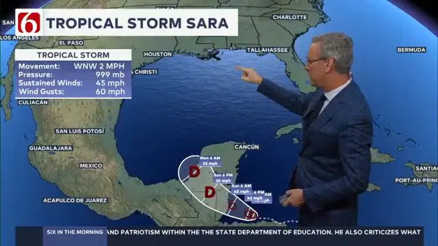
The National Hurricane Center continues to monitor Tropical Storm Sarah (without an "H"), which is moving west-northwest toward Belize and Guatemala. While the system is expected to dissipate in the Gulf of Mexico, its remnants could merge with the storm system affecting Oklahoma, enhancing rainfall across parts of the southeastern United States.
Stay weather-aware through Monday, and enjoy the mild start to the weekend before the stormy conditions arrive.
 Image Provided By: Griffin Media
---
Emergency Info: Outages Across Oklahoma:
Northeast Oklahoma has various power companies and electric cooperatives, many of which have overlapping areas of coverage. Below is a link to various outage maps.
Indian Electric Cooperative (IEC) Outage Map
Oklahoma Association of Electric Cooperatives Outage Map — (Note Several Smaller Co-ops Included)
The Alan Crone morning weather podcast link from Spotify:
https://open.spotify.com/show/0dCHRWMFjs4fEPKLqTLjvy
The Alan Crone morning weather podcast link from Apple:
Follow the News On 6 Meteorologists on Facebook!
