Tulsa weather: From Sunshine to Showers—Your Week Ahead

Will Most Areas Stay Dry?
Most of the region will more than likely stay dry through the next few days, but a few of these pop up showers can’t be ruled out later this afternoon to cool a few of us off.
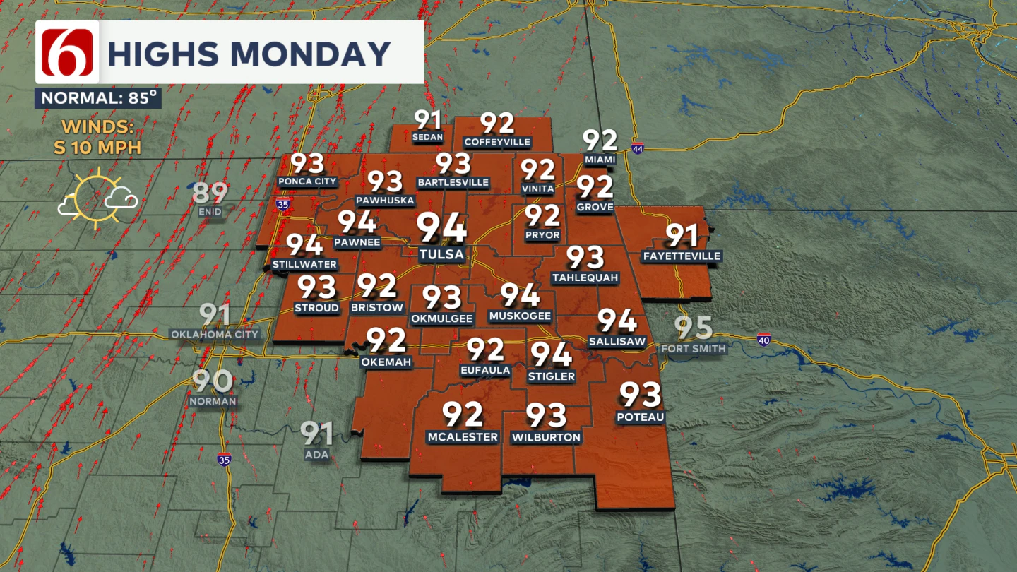
Daytime highs are expected to reach the lower 90s again today and tomorrow under mostly sunny skies, with light south winds between 5 and 12 mph.
When Will Rain Chances Increase?
Late Tuesday night into Wednesday, the mid-level ridge begins to weaken and shift away as the next trough develops across the western U.S.
This will send a few waves of instability across the central and southern Plains beginning Wednesday and continuing into early Thursday.
As a weak surface boundary develops in the Central Plains and moves southward into parts of our area, the combination of this front and an upper-level disturbance nearby will increase the chances for scattered showers and storms.
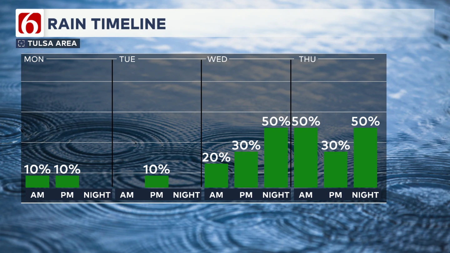
These probabilities will stay in the forecast from late Wednesday night through Thursday, and again Thursday night into early Friday.
Any Cooler Weather?
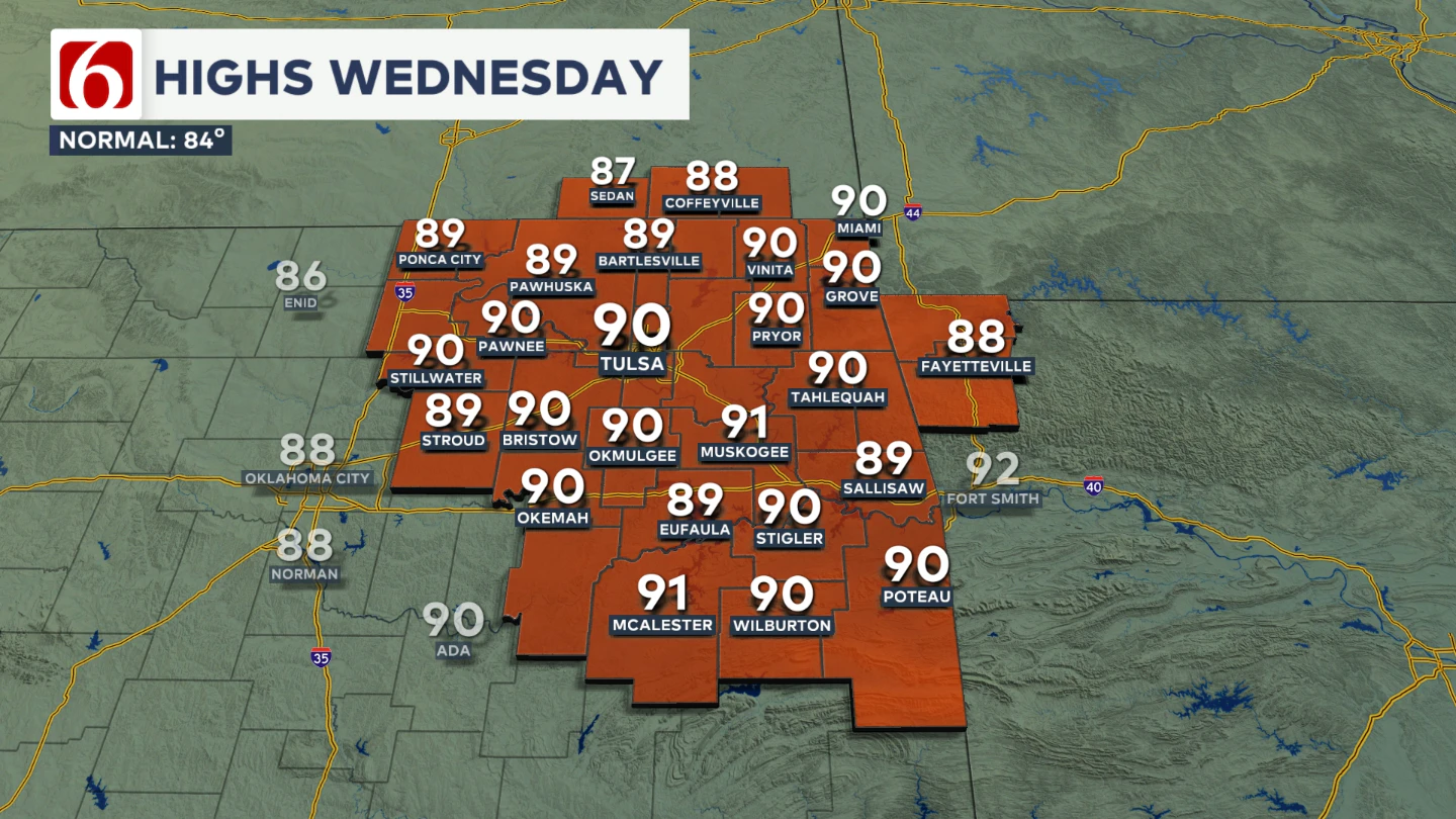
Wednesday’s highs will drop into the upper 80s to lower 90s with a light southwest breeze.
Rain chances will hover around 30 to 40 percent for the day before increasing on Wednesday and lasting late into Thursday morning.
This should have an impact on the temps with more cloud cover and potentially some rain-cooled air in spots. Thursday morning will start in the mid to upper 60s, with highs in the lower 80s.
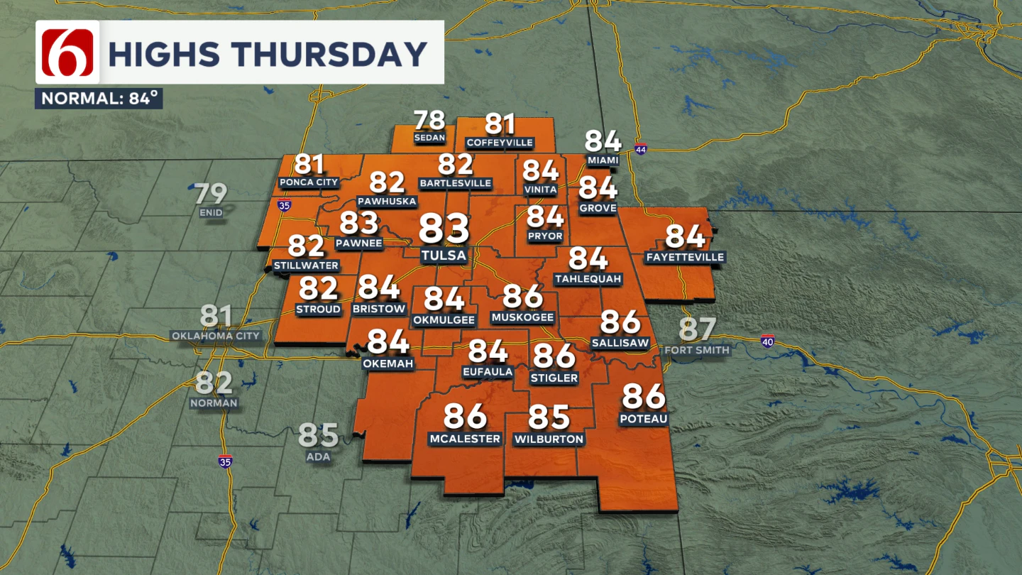
Friday morning temperatures will begin in the mid-60s, with highs climbing into the lower 80s.
What About The Weekend?
Late Friday night into Saturday, the upper-level flow will shift to more of a northwesterly direction. This pattern tends to favor late-night and early-morning storm systems brushing near our area.
As we head into the weekend, that possibility will remain on the table. Morning lows will hold in the mid-60s, with daytime highs steady in the mid-80s.
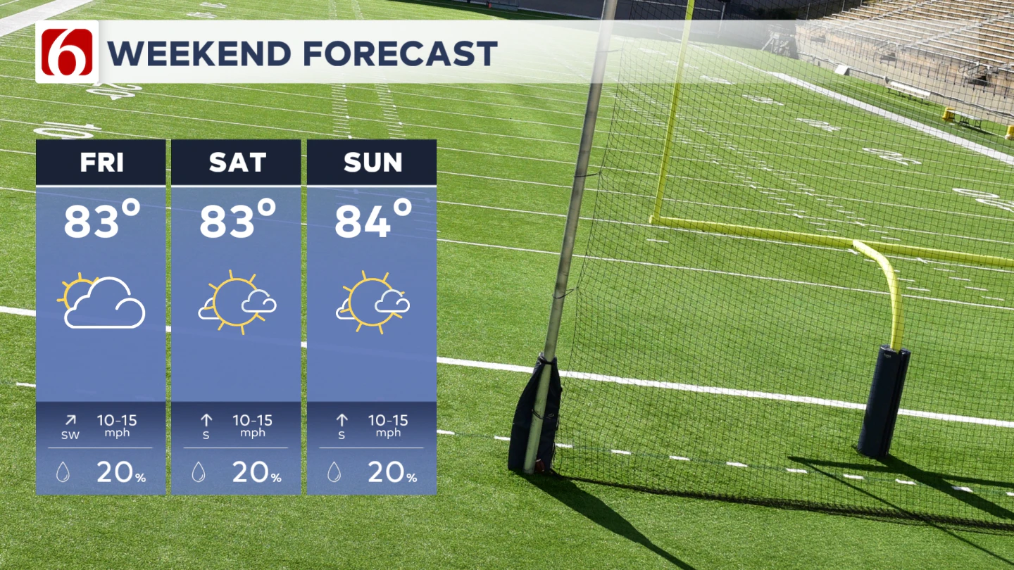
For now, our probabilities for rain and thunder will remain relatively low as confidence in the exact trajectory of any complex of storms remains low. Check this portion of the forecast later in the week, as some changes will be possible.
A weakening ridge of high pressure will keep most of the region warm and dry early this week, but a few isolated showers or storms could develop this afternoon, mainly near the Oklahoma-Arkansas state line and far western areas.
Rain chances increase midweek as a new system brings scattered storms and slightly cooler temperatures by Wednesday and Thursday
Lake Levels
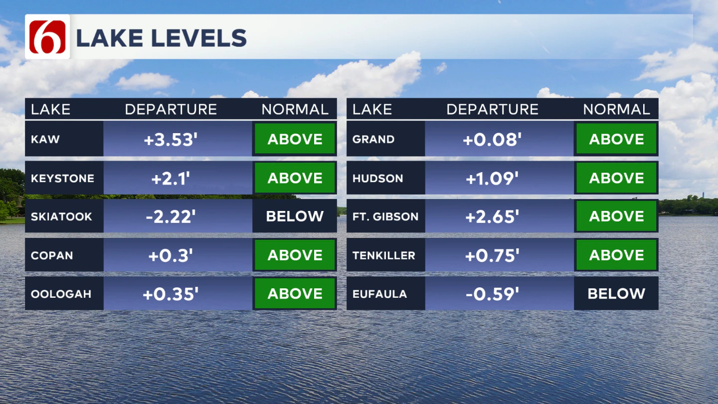
If you're making some lake recreation plans, here's an update on our area lake levels. You can look up specific lake levels anytime on our website here: https://www.newson6.com/story/5e367cbd2f69d76f6208fbb6/oklahoma-lake-levels
The Illinois River Near Tahlequah 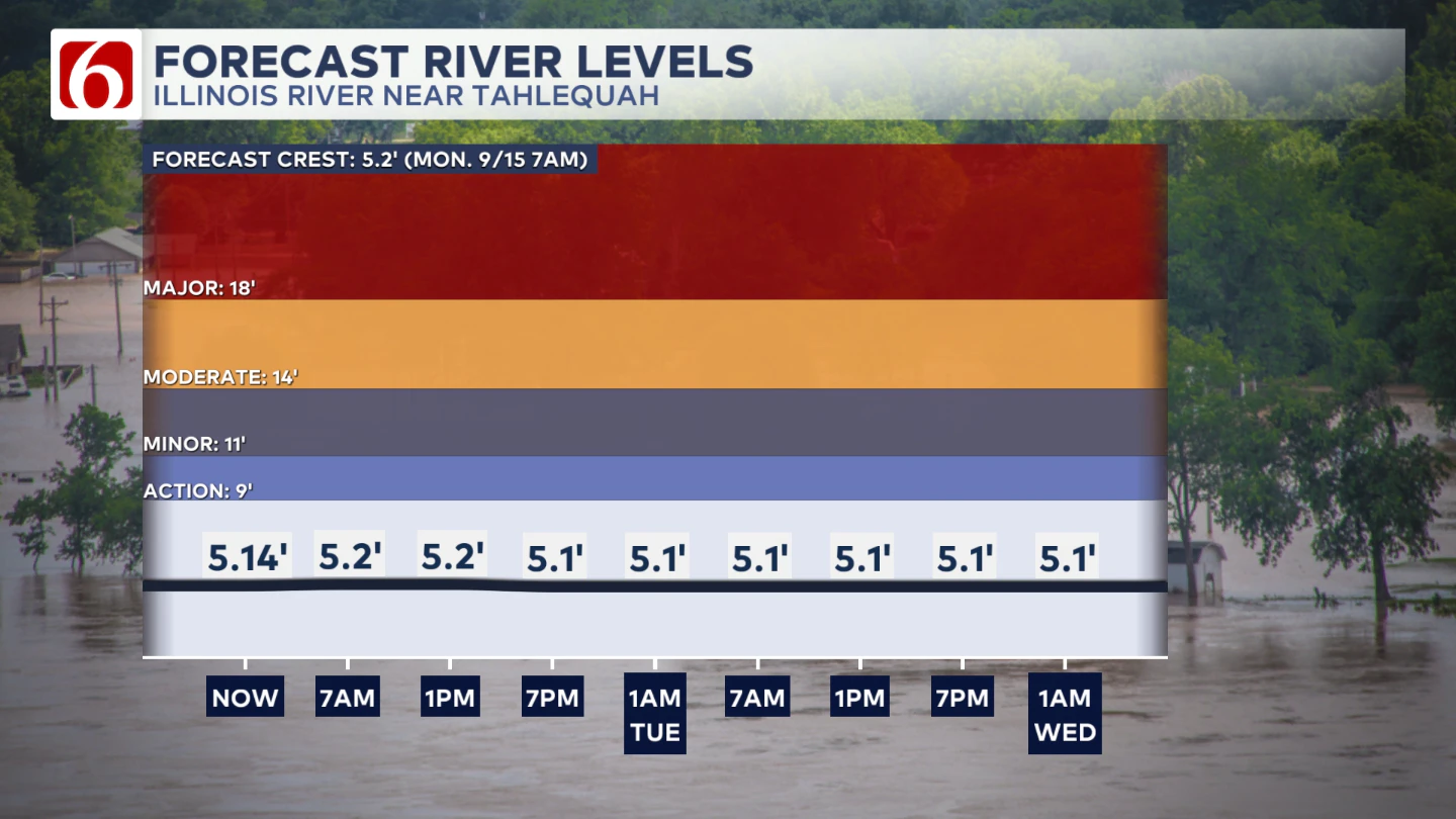
River levels should remain around 5' give or take a little bit though the next few days.
The Morning Weather Podcast:
The daily morning weather podcast briefing will remain on hold indefinitely due to ongoing internal workflow issues.
We're working to resolve these challenges as soon as possible and appreciate your patience. We apologize for the inconvenience and hope to be back soon. Thank you for your understanding.
Hot weather safety:
🔗 Oklahoma heat safety tips: How to spot and prevent heat illness
🔗 Top summer safety tips every family needs to know
🔗 'It can happen to anybody': First responders warn of hot car deaths
Need-to-know severe Oklahoma weather prep:
🔗Severe weather safety: what you need to know to prepare
🔗Tornado Watch vs. Tornado Warning: what they mean and what to do
🔗Severe weather safety: what to do before, during, and after a storm
🔗Why registering your storm shelter in Oklahoma could save your life
🔗Floodwater kills more Oklahomans than tornadoes in the last decade, here's why
🔗'Turn around, don't drown': Flood safety tips for Oklahomans
🔗5 things to know: How Oklahomans can get federal money to install storm shelters
🔗Breaking down the SoonerSafe Rebate Program: Do I qualify for a storm shelter?
Watch us on YouTube
Follow NewsOn6 on X/Twitter for automated severe weather alert posts: @NewsOn6
Emergency Info: Outages Across Oklahoma:
Northeast Oklahoma has various power companies and electric cooperatives, many of which have overlapping areas of coverage. Below is a link to various outage maps.
- PSO Outage Map
- OG&E Outage Map
- VVEC Outage Map
- Indian Electric Cooperative (IEC) Outage Map
- Oklahoma Association of Electric Cooperatives Outage Map — (Note: Several Smaller Co-ops Included)
