Chilly temps, blustery winds continue across northern Oklahoma

Another Chilly Day Across Northern Oklahoma
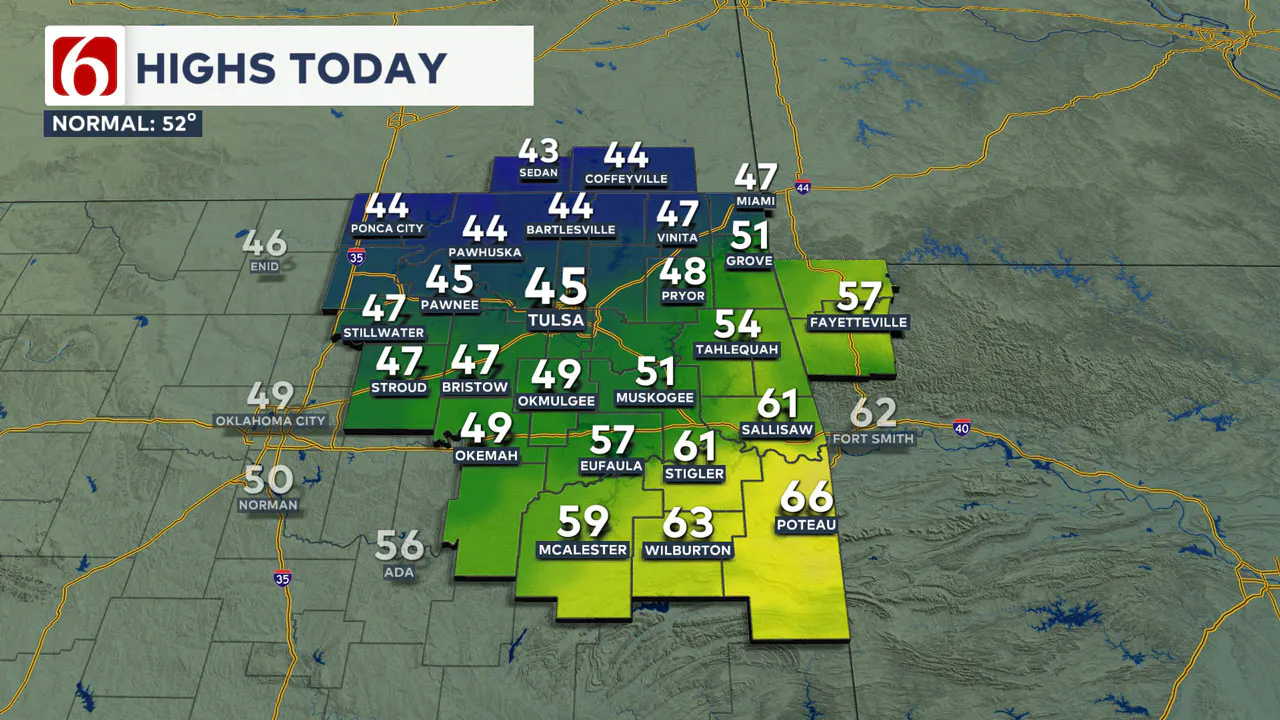
Shallow Arctic air remains entrenched across most of northern Oklahoma, keeping areas along and north of the I-40 corridor in the mid to upper 40s.
The boundary may attempt to slowly move northward later this afternoon, creating slightly warmer temperatures across far southern Oklahoma where some locations could reach the 60s along the Red River Valley by later tonight.

The eventual outcome of the front will be tied to the amount of cloud cover and early morning drizzle north of the boundary.
Temperate errors with a shallow Arctic air mass can be quite large. Regardless, we’ll prepare you for more chilly weather for most of northern Oklahoma today.
What About the wind today?
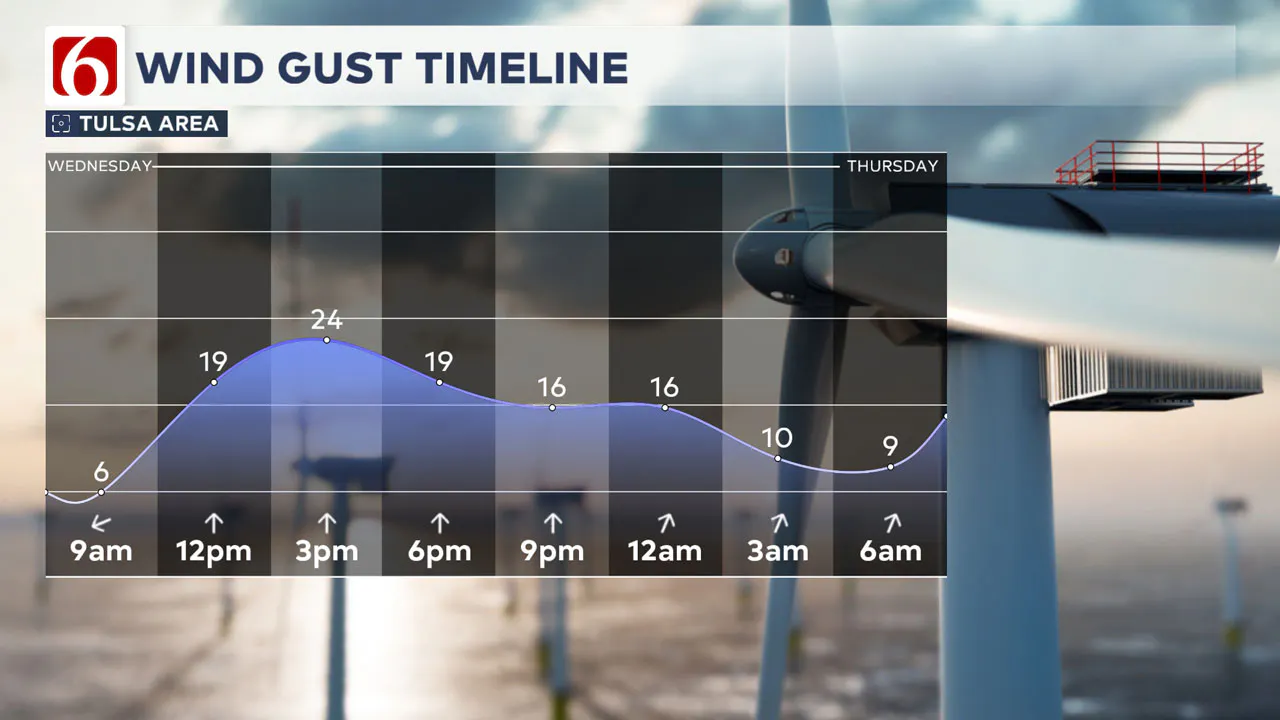
Winds will return from the south and should increase speeds to 15 to near 25 mph. This will keep conditions rather blustery across most of the area with temps mostly in the 40s across the northern sections.

Temps will reach the 50s and even 60s across southern OK later this afternoon and evening but the gusty winds will also keep blustery weather in these areas.
Another wind shift from the north arrives early Thursday morning and will drop the northern sections back into the 40s with this wind shift stalling near the I-40 corridor.
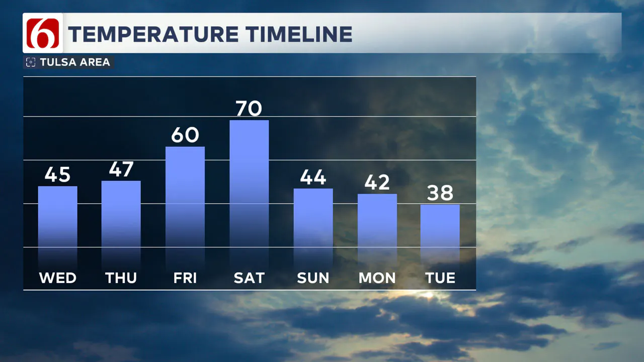
This surge of slightly colder weather should be confined to This means daytime highs Thursday should reach at least the 60s in the northern sections of the state and lower 70s in southern Oklahoma.
Any Warm-up for the weekend?
Friday and Saturday will see a slight warming trend with highs in the upper 60s or lower 70s before a stronger cold front approaches by Saturday midday.
This will bring strong north winds and falling temperatures. Saturday morning could start in the mid and upper 60s, reaching the lower 70s by midday before colder weather arrives.

What is the Forecast for Next Week?
The upper air pattern next week will support a storm system approaching from the southwest Monday night into Tuesday, yet another stronger surge of Arctic air will arrive from the north.
This pattern suggests the potential for wintry precipitation chances.
We’ll continue to monitor the forecast and keep probabilities Monday night into Tuesday relatively low, but based on this pattern, the potential for wintry weather is a possibility.
Is there a chance of wintery weather next week?
Based on the expected pattern, our probability for precipitation will increase to near a 40% chance late Monday night, Tuesday into early Wednesday.
A rain-to-wintry mix is a possibility, including some snow near or north of the area. This portion of the forecast is likely to undergo changes, so please remain aware and check the forecast often.
———
Winter Weather Preparation:
Where are the warming shelters available in Tulsa this year?
The city of Tulsa, local shelters, warming stations, and outreach teams are working to ensure access to safe, warm spaces during the cold temperatures.
>>> City of Tulsa prepares for extreme cold temperatures
>>> Warming Shelters Open Across Tulsa Amid Freezing Temperatures
Tulsa shelters and temporary warming locations are open to provide refuge. Major locations include:
- John 3:16 Mission, 506 N. Cheyenne — Open 24/7
- The Salvation Army Center of Hope, 102 N. Denver Ave. — Open 24/7
- Tulsa Day Center, 415 W. Archer St. — Open 24/7 (Pets allowed, limited capacity)
- Youth Services of Tulsa, 311 S. Madison Ave.
Temporary overflow shelters will also be open for the cold weather:
- The Merchant: 605 S. Peoria Ave., open Monday, Jan. 20, 9 a.m.–Noon; Tuesday-Friday, 9–11 a.m.
- Denver Avenue Station: 319 S. Denver Ave., open Sunday, 8:30 a.m.–8:30 p.m.; Monday-Saturday, 5:30 a.m.–11:30 p.m.
- The Station at Youth Services: 311 S. Madison Ave., open Monday-Friday, 11 a.m.–4 p.m.
- Iron Gate: 501 W. Archer St., open daily, 8:30–10:30 a.m.
- The Ministry Center: 312 S. 33rd W. Ave., open Tuesday-Thursday, 9:30 a.m.–1 p.m.
For a full list of warming station locations and hours, visit Housing Solutions’ Winter Weather Information Page.
>>> Warming Shelters, Safety Tips For Cold Temperatures This Winter In Oklahoma
Bring Pets Inside!
Winter temperatures can pose additional challenges for pets, particularly older animals or those with health conditions. Hartfield recommends:
- Wellness Checks: Ensure pets are up to date on vaccines and discuss arthritis or other cold-weather health concerns with a veterinarian.
- Outdoor Time: Monitor the duration of outdoor activities, especially for short-haired breeds or pets with conditions like diabetes or heart disease.
- Paw Care: After walks, inspect and clean paws to remove ice or de-icing chemicals that could harm your pet.
>>> Cold Weather Pet Tips: How To Keep Animals Safe During Winter Months
How Can I Protect Myself From Sickness This Winter?
The Tulsa Health Department is urging residents to receive flu and COVID-19 vaccinations to prevent respiratory illnesses as Oklahoma enters the coldest months of the year.
- Health experts say the risk of respiratory illnesses is higher during the winter, as colder weather often leads to more indoor gatherings, increasing the likelihood of viruses spreading.
- The Centers for Disease Control and Prevention says Oklahoma is one of 11 states with very high respiratory virus activity, and with flu vaccination rates lower than this time in 2024, more people have reported getting sick.
>>> How to Protect Yourself From Respiratory Illness This Winter
Emergency Info: Outages Across Oklahoma:
Northeast Oklahoma has various power companies and electric cooperatives, many of which have overlapping areas of coverage. Below is a link to various outage maps.
>>> Tulsa HVAC, Plumbing Companies Flooded With Calls During Cold Weather
- PSO Outage Map
- OG&E Outage Map
- VVEC Outage Map
- Indian Electric Cooperative (IEC) Outage Map
- Oklahoma Association of Electric Cooperatives Outage Map — (Note Several Smaller Co-ops Included)
The Alan Crone morning weather podcast link from Spotify:
https://open.spotify.com/show/0dCHRWMFjs4fEPKLqTLjvy
The Alan Crone morning weather podcast link from Apple:
Follow the News On 6 Meteorologists on Facebook!
- Meteorologist Travis Meyer
- Meteorologist Stacia Knight
- Meteorologist Alan Crone
- Meteorologist Stephen Nehrenz
- Meteorologist Aaron Reeves
- Meteorologist Megan Gold
